GeoScene Introduction
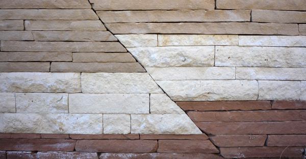
The North courtyard of the Natural Sciences building at SCC contains the GeoScene. Honors student Chris Baker has produced a narration describing the geologic history on display in the GeoScene. This narration is available in MP3 format and is given as text below. The included images show the various parts Chris emphasizes in his description.

Facing south into the geology courtyard you will see a geological structure displayed in the rock outcrop. This structure is less of a decoration and more of a story. Just by looking at the shapes, colors, and compositions of the rocks we can decipher what has happened to this piece of land over the last hundreds of millions of years.
To do this we must start with the rocks at the bottom and move our way up. This is because the oldest, and original, rocks are located at the bottom. As you can see, the bottom sheet of rock is a grainy, chocolate-colored stone. This rock is sandstone. The dark color tells us that this location was most likely a wetland or swamp. As we move up one level of rock we see a layer of red rock. This rock is also sandstone, but has a different color because over the course of millions of years the environment changed. The red, rust-like color is a result of sandstone going through the process of oxidation. Knowing this information we can assume that this land environment dried out and was exposed to atmosphere.
As we move up, the next layer of rock is where not only the color but also the type of rock changes. This light, almost white, rock is in fact limestone. Limestone is typical of a marine environment. In order to have a marine environment you must have an ocean, thus we can infer that at some point over the course of tens of millions of years the sea levels rose and this area was covered by an ocean.
The next and final layer is the color of traditional beach sand. This is, once again, a sandstone. Since this sandstone is on top of the limestone, we can make the assumption that at some point the sea levels dropped and all the beach sand was deposited. Over time all of the sand sediments were pushed together by compaction and the result was another layer of sandstone.

You may have noticed how the layers of rock follow a wave-like pattern from left to right and eventually lead to what looks like a crack in the rock. The “waves”, or folds, in the rock suggest that the compression in this area happened slowly in a hot environment with ductile rocks; which would happen at depth in the Earth.

The crack on the opposite side of the rock wall is a result of that same compression from convergent tectonic plates creating a reverse fault slip. This piece cracked rather than bent because the environment was most likely cooler and it happened quicker. This shows that the same forces on the same type of rock can have a different outcome depending on the environment.

Finally, you will see what looks like a semicircle of different colored rock. This feature is called a pluton, or in other words, a volcano that did not reach the surface. The inner-most semicircle of rock is granite. The granite resulted from where once liquid-hot magma cooled and hardened. The heat from the magma and the surrounding pressure from the other layers of rock metamorphosed the rock around the granite. The bottom and top layers around the granite are both quartzite. This quartzite came from the previously discussed sandstone reacting with the heat from the magma and the pressure from the surrounding rocks changing the sandstone into quartzite. As you may have noticed, the bottom layer of quartzite is darker than the top layer. This is because the bottom layer came from a sandstone that was originally darker in color. The middle layer around the granite is marble. This marble resulted from the layer of limestone interacting with the heat and pressure in the same way as the sandstone. However, because it was limestone it metamorphosed into marble rather than quartzite.
Research Results showing the effectiveness of the GeoScene as a teaching and learning tool (in review):
*Abstract*
Within the discipline of geology, geologic field trips are among the most beneficial learning experiences for students, but they are also difficult environments to maximize learning. This action research study explored improving the application of geological concept understanding from a traditional laboratory setting to an authentic field environment by utilizing an artificial outcrop, called the GeoScene, as an intervention between the two. The study employed a mixed-methods action research design, collecting and analyzing multiple qualitative and quantitative data sources to determine whether the intervention affected student comprehension and interpretation of geologic phenomena in an authentic field environment, and if so, how.
Students enrolled in two different sections of a non-major college level geology laboratory course, which shared a common lecture, were used as control and treatment groups. The treatment group (n=13) experienced a short, 15 minute intervention at the GeoScene to attempt to improve performance in an authentic field environment. Comparisons were made to a control group (n=12), who did not participate in GeoScene activities, but completed additional exercises and applications in the traditional laboratory setting.
The quantitative data collected suggest that the treatment group outperformed the control group in geology content related skills taught in the laboratory, and supported by the GeoScene, while in an authentic field environment (p≤0.01, δ=0.507). Qualitative data sources suggested that the GeoScene treatment was a positive addition to the laboratory studies and improved the student transition to the field environment by: (1) reducing anxiety and decreasing heightened stimulus associated with the novelty of the authentic field environment, (2) allowing a physical transition between the laboratory and field that shifted concepts learned in the lab to the field environment, and (3) improving critical analysis of geologic phenomena.